To main content

Dredging of sediments, Miami river

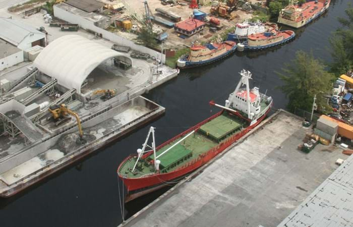
The Miami River, which flows through an urban industrial area of Miami, Florida, had not been dredged since the area was built in 1934. In 1990 the US Army Corps of Engineers advised the city that the sediment had to be removed from the river as it was impeding shipping. There was one caveat however: the sediment, contaminated with heavy metals, pesticides and oil, could not be placed in the ocean.

In 2004 a consortium of Weston Solutions and Bean Environmental was awarded the job of restoring the river to its original depth. The two companies were jointly responsible for the dredging, transportation and processing of around 540,000 m3 of contaminated sediment. Boskalis Dolman was consulted on the project at an early stage and was subsequently commissioned as subcontractor to Bean Environmental to erect a transshipment and processing plant for the dredged sediments. A Mobile Soil Washing Plant (MSWP) was flown in and assembled on the banks of the Miami River. This MSWP combines coarse fraction separation and mechanical dewatering. Coarse fraction separation involves the precise separation of the various sub-flows using a rotating wash and sieve drum, shaker screens and hydrocyclones. Mechanical dewatering is used to process the remainder of the contaminated sludge. As a result of this processing by the MSWP, a large proportion of the resulting sub-flows could be beneficially used in the community at little extra cost to the project. In addition, we were able to significantly reduce the original volume of contaminated dredged sediments, which had a direct effect on cost-efficiency.

Related projects

Selected filters
Newbiggin_header.jpg

Beach replenishment, Newbiggin Bay

Newbiggin by the Sea was once a seaside resort, with the residential area focused around the bay. The beach has severely eroded over the years. If the coastline would continue to recede, sea walls could begin to collapse, imperilling coastline properties. The falling beach levels and increased risk of seawall failure led to a strategy and proposal to import beach fill, along with construction of an offshore breakwater to retain material. Boskalis expanded the existing beach and protected it from erosion.

AA_hoofdfoto_header.jpg

Dredging, reclamation,
reconstruction and environmental
monitoring works, Vilufushi

The Republic of the Maldives consists of 1,190 small coral islands grouped into 26 atolls. Only 200 islands are inhabited. On 26 December 2004, a tsunami originating from Indonesian waters struck the Maldives. This natural disaster had major economic, social and environmental consequences. Of the 200 inhabited islands, 13 were totally destroyed and 56 suffered major damage, including the island of Vilufushi in Thaa Atoll. Houses and infrastructure were heavily damaged. All the surviving residents had to be evacuated to the neighboring island of Buruni to the west of Vilufushi. The government of the Maldives decided to reconstruct the entire island and to extend it considerably by landfilling the shallow reef. Boskalis International was appointed for this work.

_DSF0040_header.jpg

Removal of overburden for bauxite mine, Klaverblad

Surinam’s alumina exports accounted for 70% of the total export figures. Aluminum is produced from bauxite and so bauxite mining was one of the country's vital industries. Growing demand for metals in fast-growing economies led BHP Billiton Maatschappij to open up a fourth mine alongside the three bauxite mines they already operated in Surinam. The mine location on the banks of the River Surinam was covered by a thick layer of clay. Borehole information and surveys showed that an area of about 130 ha needed to be cleared of bush, followed by the removal of the top layer and dewatering to an average depth of 14 meters. Safety and the prevention of dredging-related turbidity in the river were areas requiring particular attention.

Beachway_2002_67_header.jpg

Maintenance, Martin Garcia channel

The Rio Parana is the principal fairway for transporting the massive exports of agricultural products from the fertile plains of Argentina, Bolivia and Paraguay. Ocean going vessels sail the Parana River to the loading terminals in the Rosario region, situated 300 km upstream from the Rio de La Plata estuary. Both the Rio Parana and the Rio Uruguay flow into the Rio de la Plata. The Rio de la Plata can be described as a shallow inland-sea with natural depths between 1 and 6 m. The mouth of the Rio Parana from the Ocean is approximately 250 km. The Rio de la Plata has a width of 40 km on the upstream side near Buenos Aires and about 200 km downstream at the level of Montevideo.

Picture2_header.jpg

Dredging, reclamation and dewatering works, Gas-to-Liquids facility Escravos

The Escravos Gas-to-Liquids facility (EGTL) converts natural gas feed into high quality, environmentally superior, liquid GTL fuel, naphtha, and LPG products. The facility feed is approximately 320 million SCFD of natural gas and the facility produces approximately 33,000 BPD of products. The EGTL facility will be built on the north bank of the Escravos River tidal outlet, in the Niger Delta about 2 kilometers north of its confluence with the Atlantic Ocean on the Bight of Benin, approximately 100 nautical miles south east of Lagos, and 37 nautical miles west of Warri, Nigeria.

2007-02-22_header.jpg

Land reclamation, Half Moon Bay Island Manama

‘Half Moon Bay’ island is situated in the Seef area of Manama in the Kingdom of Bahrain. The purpose of the island is to accommodate a future 5 Star Hotel development as well as several villas. Engineering Department Hydronamic was engaged to develop the design of the island and to provide advisory services to Boskalis Westminster Middle East. Through good co-operation between the design engineers of Hydronamic and the construction team of Boskalis Westminster Middle East innovative ideas were developed which could be integrated into the rock protection design resulting in the successful and efficient construction with significant cost savings to the project.