To main content

Port access channel dredging, Walvis Bay

The port of Walvis Bay is a naturally sheltered deepwater harbor on the west coast of Africa. The port is part of a transit route linking Southern Africa, Europe and the Americas and it is Namibia’s largest commercial port, handling around 5 million tons of cargo each year. The container terminal can accommodate a throughput of about 250,000 containers per year.

Work method

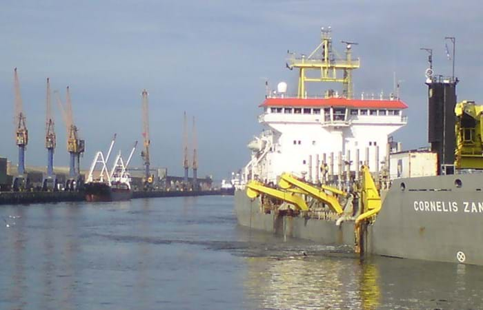
The contract for the dredging works was awarded to Boskalis International in mid-2010. The works included capital dredging in the entrance channel, allowing larger vessels to enter the port. Deepening of the channel was required to a design depth varying from 14.0 -CD to 14.4 m -CD. All the dredged material had to be taken to a designated offshore spoil site located at a sailing distance of approximately 13 km. The material dredged in the outer channel was very soft and can be typically described as ooze, or pelagic sediment composed of planktonic debris. In other areas very compact sandy material was found, especially in deeper parts of the profile. The ooze material contained large amounts of H2S and methane, and this was the major challenge on the project. A total of 1.8 million m3 of material was dredged during the four-month execution period. All the dredging works were executed with a Trailing Suction Hopper Dredger. The first TSHD deployed on site was the Argonaut, which was followed by the Cornelis Zanen halfway through the project. These vessels were perfectly adapted for dredging in the given conditions, especially in the relatively narrow main channel. A local plough barge with a 6.5 t plough and a 10 t bollard pull tug were hired through to the end of the project for the purposes of handing over the site in accordance with the contract specifications.

Related projects

Selected filters
Newbiggin_header.jpg

Beach replenishment, Newbiggin Bay

Newbiggin by the Sea was once a seaside resort, with the residential area focused around the bay. The beach has severely eroded over the years. If the coastline would continue to recede, sea walls could begin to collapse, imperilling coastline properties. The falling beach levels and increased risk of seawall failure led to a strategy and proposal to import beach fill, along with construction of an offshore breakwater to retain material. Boskalis expanded the existing beach and protected it from erosion.

AA_hoofdfoto_header.jpg

Dredging, reclamation,
reconstruction and environmental
monitoring works, Vilufushi

The Republic of the Maldives consists of 1,190 small coral islands grouped into 26 atolls. Only 200 islands are inhabited. On 26 December 2004, a tsunami originating from Indonesian waters struck the Maldives. This natural disaster had major economic, social and environmental consequences. Of the 200 inhabited islands, 13 were totally destroyed and 56 suffered major damage, including the island of Vilufushi in Thaa Atoll. Houses and infrastructure were heavily damaged. All the surviving residents had to be evacuated to the neighboring island of Buruni to the west of Vilufushi. The government of the Maldives decided to reconstruct the entire island and to extend it considerably by landfilling the shallow reef. Boskalis International was appointed for this work.

_DSF0040_header.jpg

Removal of overburden for bauxite mine, Klaverblad

Surinam’s alumina exports accounted for 70% of the total export figures. Aluminum is produced from bauxite and so bauxite mining was one of the country's vital industries. Growing demand for metals in fast-growing economies led BHP Billiton Maatschappij to open up a fourth mine alongside the three bauxite mines they already operated in Surinam. The mine location on the banks of the River Surinam was covered by a thick layer of clay. Borehole information and surveys showed that an area of about 130 ha needed to be cleared of bush, followed by the removal of the top layer and dewatering to an average depth of 14 meters. Safety and the prevention of dredging-related turbidity in the river were areas requiring particular attention.

Beachway_2002_67_header.jpg

Maintenance, Martin Garcia channel

The Rio Parana is the principal fairway for transporting the massive exports of agricultural products from the fertile plains of Argentina, Bolivia and Paraguay. Ocean going vessels sail the Parana River to the loading terminals in the Rosario region, situated 300 km upstream from the Rio de La Plata estuary. Both the Rio Parana and the Rio Uruguay flow into the Rio de la Plata. The Rio de la Plata can be described as a shallow inland-sea with natural depths between 1 and 6 m. The mouth of the Rio Parana from the Ocean is approximately 250 km. The Rio de la Plata has a width of 40 km on the upstream side near Buenos Aires and about 200 km downstream at the level of Montevideo.

Picture2_header.jpg

Dredging, reclamation and dewatering works, Gas-to-Liquids facility Escravos

The Escravos Gas-to-Liquids facility (EGTL) converts natural gas feed into high quality, environmentally superior, liquid GTL fuel, naphtha, and LPG products. The facility feed is approximately 320 million SCFD of natural gas and the facility produces approximately 33,000 BPD of products. The EGTL facility will be built on the north bank of the Escravos River tidal outlet, in the Niger Delta about 2 kilometers north of its confluence with the Atlantic Ocean on the Bight of Benin, approximately 100 nautical miles south east of Lagos, and 37 nautical miles west of Warri, Nigeria.

2007-02-22_header.jpg

Land reclamation, Half Moon Bay Island Manama

‘Half Moon Bay’ island is situated in the Seef area of Manama in the Kingdom of Bahrain. The purpose of the island is to accommodate a future 5 Star Hotel development as well as several villas. Engineering Department Hydronamic was engaged to develop the design of the island and to provide advisory services to Boskalis Westminster Middle East. Through good co-operation between the design engineers of Hydronamic and the construction team of Boskalis Westminster Middle East innovative ideas were developed which could be integrated into the rock protection design resulting in the successful and efficient construction with significant cost savings to the project.