To main content

Port development, Sevilla

Seville is located 80 km land inwards and it is Spain’s only commercial river port. Access is along the Rio Guadalquivir. The current dimensions and depth of the port impose limitations on the breadth and draughts of the vessels that use it, putting the future of the port at risk. So the Port Authority developed a New Maritime Approach that provides for the deepening and widening of the approaches to the port.

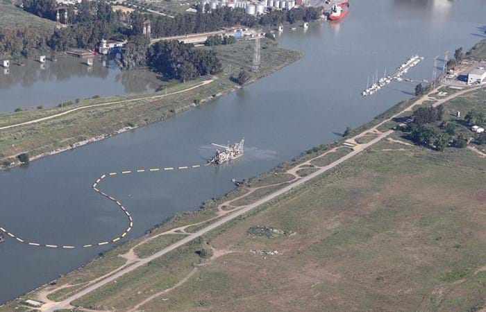
The complete dredging project, amounting to approximately EUR 15 million, started with maintenance dredging in the entrance channel and the removal of the top layer of the construction pit for the future lock down to a depth of about 5.50 m. A trench with a depth of 15.5 m was then dredged for the foundations of the dike round the construction pit. After the completion of the lock, the new entrance channels will be dredged to a depth of 9.10 m downstream and 7.70 m upstream. The dredged material was pumped to fill areas (recintos) around the construction area, sometimes over distances of more than 2000 m. The work was done by Boskalis’ 3,400 kW dieselelectric CSD Para I, a dredger with a maximum working depth of 17.50 m. The ship is equipped with a special cooling system to cope with tropical temperatures, which is ideal for the hot summers in Seville, where temperatures can reach 45oC. Before this dredging work started, the ship was also adapted to comply with the client’s requirements relating to noise reduction.

Related projects

Selected filters
DSC04359_header.jpg

Port access channel dredging, Walvis Bay

The port of Walvis Bay is a naturally sheltered deepwater harbor on the west coast of Africa. The port is part of a transit route linking Southern Africa, Europe and the Americas and it is Namibia’s largest commercial port, handling around 5 million tons of cargo each year. The container terminal can accommodate a throughput of about 250,000 containers per year.

IMG_8772_header.jpg

Coastal protection, St. Petersburg

St. Petersburg is a UNESCO World Heritage City, but its location along the River Neva means that it has been threatened by over 300 floods since its founding by Peter the Great in 1703. The completion of the new 25 km long storm-surge barrier across the Gulf of Finland ensures that the city will no longer be vulnerable to high tides and devastating floods. As a result of the new Flood Protection Barrier, however, the old winding access channel had to be replaced with a new, straighter, more easily navigable channel.

Delflandse_coast___3__header.jpg

Coastal protection, Delfland coast

In August 2008 Van Oord and Royal Boskalis Westminster N.V. have been awarded a contract by the Dutch Directorate General for Public Works and Water Management to reinforce a weak link in the Delflandse coast . The contract is worth EUR 120 million of which Van Oord and Boskalis have an equal share.

IMG_1888_header.jpg

Cleanup, Zellingwijk area

The Zellingwijk quarter of the village of Gouderak was built in the middle of the last century. In the early 1980s it became clear that the soil underneath this residential area was heavily contaminated as a result of the dumping of waste - mainly mineral oils and pesticides. The homes built on the site were subsequently demolished in the mid-1980s. Pending definitive remediation work, a layer of concrete / asphalt was applied to seal the site.

DSCF0279_header.jpg

Overview activities, Bahrain

The Kingdom of Bahrain is an island located in the Gulf, east of Saudi Arabia and north of Qatar and connected with its neighbour Saudi Arabia since the year 1980 with a 25 km long causeway. The archipelago consists of some 30 islands with a total of 160 km of shoreline and has a population of 800,000. Whereas the surface of Bahrain in the year 1960 was around 650 km2, the last decennia have seen a steady increase in the surface till a respectable figure of 740 km2 in 2007. This increase has been achieved by a various number of small and mayor reclamation projects.

37ac96e429c252fd55f1136ce6374c9e_image_header.jpg

Early works for LNG plant, Brass Island

The Brass LNG Project’s objective is to construct a LNG Complex on Brass Island, Bayelsa State, Nigeria, and in so doing, develop Nigeria’s abundant gas resources, reduce the adverse effect of gas flaring on the environment, and provide social-economic benefits to the local and wider Nigerian communities. The LNG complex will be designed to produce approximately 10 million tons per annum (MTPA) of LNG, as well as LPG and Residual NGL products.