To main content

Port extension, Port of Gävle

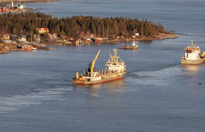
The Port of Gävle is located on the east coast of Sweden in the Gulf of Bothnia, facilitating Swedish imports and exports. The client wished to improve maritime safety and accessibility, and to increase the throughput of goods in this harbor.

The Swedish Maritime Administration awarded Boskalis Sweden AB the contract to achieve these objectives by widening and deepening of the approach to the Port of Gävle and upgrading the navigation aids.

Project highlights

  • Innovative lighthouse structures were designed, constructed and placed during the project.
  • Up to ten vibration monitoring devices to log the actual vibrations during each and every of the underwater blasts made safe and efficient blasting close to 61 properties possible.
  • Hydronamic was involved, together with the client, in establishing an extensive turbidity monitoring program to minimize the impact on the environment. Several thousand water samples were tested, none of which resulted in any interruptions to the works, mainly due to the use of the specially designed environmental grab, which reduces the release of suspended solids during the excavation of the seabed material and therefore limits the potential for the spread of any potentially contaminated material.
  • 150 boulders > 5 m3 were dredged
  • The harsh Baltic weather conditions forced us to interrupt the work on two occasions.
  • 500,000 m3 of contaminated material was dredged and separated from the open environment carefully.

And last but not least: there were no major accidents during the project.

Related projects

Selected filters
IMG_0064_header.jpg

Port development, Gothenburg

Gothenburg turns around some 34 million tons of cargo annually, including 700,000 TEU (containers), and is unique in the region. With regard to the variety and frequency of calls from intercontinental liner trade the port is outstanding in Sweden. The port can be reached from the sea via two different channels: Torshamnen Fairway and Böttö Fairway. From a navigational point of view both channels needed to be deepened and widened at a number of places. Thus there were two good reasons to enhance the fairways: securing the port’s future as the premier port for liner trade and creating safer navigation. This resulted into a major dredging contract which was awarded in June 2002 to Boskalis Westminster Dredging Company.

03_header.jpg

Remediation, Urk harbor area

Many port areas requiring dredging works have been forced to put projects on hold due to the absence of an environmentally safe solution for the disposal or processing of contaminated sediments. While this is a global problem, the availability of central, large-scale repositories in the Netherlands has transformed disposal economics at the national level. Nevertheless, the high level of debris encountered during the dredging of ports and harbors remains a major challenge to all contractors. The hydraulic transport of sediments with a high debris content is impossible.

Pusan_New_Port_5_header.jpg

Port construction, Pusan

The 4th largest container terminal in the world is located in the South East of the South Korean peninsula at Busan. As the old port is completely surrounded by the metro-city, expansion of the old port is restricted. To solve the chronic phenomenon of cargo congestion MOMAF (Ministry of Marine and Fisheries) decided in 1997 to construct a new port situated 20 km west of Busan with a final total handling capacity of 4.6 million TEU and total expenses of 4.2 billion USD.

mejillones_5_header.jpg

Port construction and environmental monitoring, Mejillones

Boskalis International B.V. was working as a subcontractor to the Chilean civil contractor Empresa Constructora BELFI SA, which was awarded the contract to construct phase 1 of the New Mega Port Mejillones. This port has been developed in order to ship the copper of the Chilean mining corporation CODELCO.

Luchtfoto_milieubrochure_header.jpg

Cleanup, Ketelmeer

Ketelmeer, a lake in the Netherlands with a length of some 10 kilometers and a width varying from two to three kilometers, separates the North Eastern and Southern Polders constructed during the late 1960s and early 1970s. It is a major example of the problem of 'historic pollution'. Lake Ketelmeer receives the waters of the Rijn and IJssel and over a period of three or more decades, tens of millions of cubic meters of highly contaminated sediments entered Ketelmeer from hundreds of upstream locations. The bottom was covered by polluted sediments to an average depth of 50 cm. A significant proportion of this material had to be removed, or capped by the cleaner sediments of recent years, if a normal aquatic environment was to be restored.

Warnow_Tunnel__3__header.jpg

Tunnel construction Warnow, Rostock

The Warnow Tunnel is located in Rostock, Germany, at the old mouth of the river Warnow in the Baltic Sea. In the DDR period this area grew out to be the main harbor of East-Germany. After the 'turn' (die Wende) in 1989 the port more or less died. Goods came cheaper and quicker from Rotterdam, Bremen and Hamburg by rail.