To main content

Dredging, reclamation and
shore protection, Soyo LNG

Angola is one of the world’s deep water oil exploration ‘hot spots’. More than 50 significant oil discoveries in Blocks 14, 15, 17 and 18 are believed to contain at least 10 billion barrels of oil. With the increase in oil production comes large quantities of associated gas. Historically, in the absence of a local market, associated gas has been flared or reinjected into the reservoirs. Sonangol, the state oil company, and some of its oil producing partners developed the Angola LNG Project to reduce flaring of gas and curtail gas injection. Angola LNG is a joint venture project involving the major oil producers in the country. Sonangol and Chevron are the co-leaders of the project; the other partners are Total, ENI and BP.

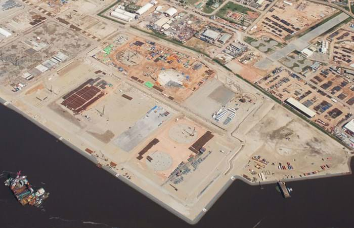
The LNG plant will be built on a site south of the Congo River, in Zaire Province, West of the city of Soyo. The plant will have a capacity of 5.0 million tonnes per year, a full containment LNG storage, a LPG and condensate storage and a loading jetty. Angola LNG Limited awarded the contract for preparation of the plant site to the joint venture of Boskalis International B.V. and Jan de Nul Dredging Ltd., in which Boskalis had the lead. The preparation of the plant site consisted of widening and deepening the existing shipping channel in the ‘Baia de Diogo Cão’; dredging a turning basin for the LNG facility and improving the existing Kwanda Basin. The volume dredged was 28 million m3. The land reclamation works for the LNG facility consisted of raising 125 hectares of existing land on the north side of Kwanda Island and creating 65 hectares new land in the Congo river estuaria. The reclamation works required a total of 7 million m3 suitable material. Besides dredging and land reclamation, the works involved the construction of 1.5 km shore and slope protection, the installation of 4.5 km drainage around the fill areas, the installation and monitoring of geo instrumentation, the installation of a concrete oil/water separator and floodvalve as well as the placing of navigation aids in the channel and basins. The design and construct works were awarded by the end of January 2007, and all operations had to be completed by December 2008. The works entailed a highly challenging timeline and required a high degree of flexibility as the scope of work changed over time. This demanded maximum adaptability and fast decisionmaking, particularly in the design phase. Extensive environmental mitigation measures presented a further challenge, as did the unexploded bombs and other ordnance lying on the seabed in the area, a legacy from Angola’s 27-year civil war, which ended in 2002.

Related projects

Selected filters
DSC04359_header.jpg

Port access channel dredging, Walvis Bay

The port of Walvis Bay is a naturally sheltered deepwater harbor on the west coast of Africa. The port is part of a transit route linking Southern Africa, Europe and the Americas and it is Namibia’s largest commercial port, handling around 5 million tons of cargo each year. The container terminal can accommodate a throughput of about 250,000 containers per year.

IMG_8772_header.jpg

Coastal protection, St. Petersburg

St. Petersburg is a UNESCO World Heritage City, but its location along the River Neva means that it has been threatened by over 300 floods since its founding by Peter the Great in 1703. The completion of the new 25 km long storm-surge barrier across the Gulf of Finland ensures that the city will no longer be vulnerable to high tides and devastating floods. As a result of the new Flood Protection Barrier, however, the old winding access channel had to be replaced with a new, straighter, more easily navigable channel.

Delflandse_coast___3__header.jpg

Coastal protection, Delfland coast

In August 2008 Van Oord and Royal Boskalis Westminster N.V. have been awarded a contract by the Dutch Directorate General for Public Works and Water Management to reinforce a weak link in the Delflandse coast . The contract is worth EUR 120 million of which Van Oord and Boskalis have an equal share.

IMG_1888_header.jpg

Cleanup, Zellingwijk area

The Zellingwijk quarter of the village of Gouderak was built in the middle of the last century. In the early 1980s it became clear that the soil underneath this residential area was heavily contaminated as a result of the dumping of waste - mainly mineral oils and pesticides. The homes built on the site were subsequently demolished in the mid-1980s. Pending definitive remediation work, a layer of concrete / asphalt was applied to seal the site.

DSCF0279_header.jpg

Overview activities, Bahrain

The Kingdom of Bahrain is an island located in the Gulf, east of Saudi Arabia and north of Qatar and connected with its neighbour Saudi Arabia since the year 1980 with a 25 km long causeway. The archipelago consists of some 30 islands with a total of 160 km of shoreline and has a population of 800,000. Whereas the surface of Bahrain in the year 1960 was around 650 km2, the last decennia have seen a steady increase in the surface till a respectable figure of 740 km2 in 2007. This increase has been achieved by a various number of small and mayor reclamation projects.

37ac96e429c252fd55f1136ce6374c9e_image_header.jpg

Early works for LNG plant, Brass Island

The Brass LNG Project’s objective is to construct a LNG Complex on Brass Island, Bayelsa State, Nigeria, and in so doing, develop Nigeria’s abundant gas resources, reduce the adverse effect of gas flaring on the environment, and provide social-economic benefits to the local and wider Nigerian communities. The LNG complex will be designed to produce approximately 10 million tons per annum (MTPA) of LNG, as well as LPG and Residual NGL products.