To main content

Port development, Mombasa

The Port of Mombasa is currently the biggest port on the coast of East Africa north of Durban, and the only international port in Kenya. It is now in the throes of a huge expansion drive to both increase cargo handling capacity and accommodate Panamax and Post Panamax vessels. The port is a transit route for, mainly, Uganda, Rwanda, South Sudan and Northern Tanzania. The current container terminal has an installed capacity of 250,000 TEU but handled more than 770,000 TEU in 2011. The port will raise its profile as a regional hub by building a second container terminal with a capacity of 1.2 million TEU. The port authority decided to construct the container terminal in phases.

Challenges

The main challenge on the project was the fact that Boskalis had to work with weak subsoil with a low bearing capacity. There were also environmental challenges because the sand borrow area was situated between marine reserve parks.

Work method

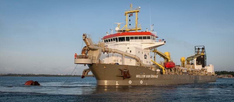
On 1 August 2012, Boskalis International B.V. signed the sub-contract for the dredging and reclamation works for the first construction phase for the second container terminal. Before construction of the quay walls, three deep trenches were dredged by TSHDs Argonaut and Willem van Oranje to remove the weak subsoil and replace it with sand. Boskalis soil specialists invested large amounts of time and energy in sourcing suitable sand in the immediate vicinity of the project. After the removal of 1 million m3 of soil, the soil improvement area was filled with offshore sand by TSHD Willem van Oranje and a spray pontoon. Reclamation had to take place very carefully to avoid mud slides and circular slip. During reclamation to +1 m CD, the spray pontoon SP10, positioned on six anchors, was used to apply layers of 75 cm; that part of the work was completed successfully on 11 March 2013. The remaining sand was applied in layers up to +5.5 m CD using land pipelines. Boskalis successfully met some challenges with extreme local settlements. The +5,5 m CD level was completed on 7 May 2013. This activity was followed by a surcharge fill to a maximum of +11 m CD to reduce settlement time.

Related projects

Selected filters
Newbiggin_header.jpg

Beach replenishment, Newbiggin Bay

Newbiggin by the Sea was once a seaside resort, with the residential area focused around the bay. The beach has severely eroded over the years. If the coastline would continue to recede, sea walls could begin to collapse, imperilling coastline properties. The falling beach levels and increased risk of seawall failure led to a strategy and proposal to import beach fill, along with construction of an offshore breakwater to retain material. Boskalis expanded the existing beach and protected it from erosion.

AA_hoofdfoto_header.jpg

Dredging, reclamation,
reconstruction and environmental
monitoring works, Vilufushi

The Republic of the Maldives consists of 1,190 small coral islands grouped into 26 atolls. Only 200 islands are inhabited. On 26 December 2004, a tsunami originating from Indonesian waters struck the Maldives. This natural disaster had major economic, social and environmental consequences. Of the 200 inhabited islands, 13 were totally destroyed and 56 suffered major damage, including the island of Vilufushi in Thaa Atoll. Houses and infrastructure were heavily damaged. All the surviving residents had to be evacuated to the neighboring island of Buruni to the west of Vilufushi. The government of the Maldives decided to reconstruct the entire island and to extend it considerably by landfilling the shallow reef. Boskalis International was appointed for this work.

_DSF0040_header.jpg

Removal of overburden for bauxite mine, Klaverblad

Surinam’s alumina exports accounted for 70% of the total export figures. Aluminum is produced from bauxite and so bauxite mining was one of the country's vital industries. Growing demand for metals in fast-growing economies led BHP Billiton Maatschappij to open up a fourth mine alongside the three bauxite mines they already operated in Surinam. The mine location on the banks of the River Surinam was covered by a thick layer of clay. Borehole information and surveys showed that an area of about 130 ha needed to be cleared of bush, followed by the removal of the top layer and dewatering to an average depth of 14 meters. Safety and the prevention of dredging-related turbidity in the river were areas requiring particular attention.

Beachway_2002_67_header.jpg

Maintenance, Martin Garcia channel

The Rio Parana is the principal fairway for transporting the massive exports of agricultural products from the fertile plains of Argentina, Bolivia and Paraguay. Ocean going vessels sail the Parana River to the loading terminals in the Rosario region, situated 300 km upstream from the Rio de La Plata estuary. Both the Rio Parana and the Rio Uruguay flow into the Rio de la Plata. The Rio de la Plata can be described as a shallow inland-sea with natural depths between 1 and 6 m. The mouth of the Rio Parana from the Ocean is approximately 250 km. The Rio de la Plata has a width of 40 km on the upstream side near Buenos Aires and about 200 km downstream at the level of Montevideo.

Picture2_header.jpg

Dredging, reclamation and dewatering works, Gas-to-Liquids facility Escravos

The Escravos Gas-to-Liquids facility (EGTL) converts natural gas feed into high quality, environmentally superior, liquid GTL fuel, naphtha, and LPG products. The facility feed is approximately 320 million SCFD of natural gas and the facility produces approximately 33,000 BPD of products. The EGTL facility will be built on the north bank of the Escravos River tidal outlet, in the Niger Delta about 2 kilometers north of its confluence with the Atlantic Ocean on the Bight of Benin, approximately 100 nautical miles south east of Lagos, and 37 nautical miles west of Warri, Nigeria.

2007-02-22_header.jpg

Land reclamation, Half Moon Bay Island Manama

‘Half Moon Bay’ island is situated in the Seef area of Manama in the Kingdom of Bahrain. The purpose of the island is to accommodate a future 5 Star Hotel development as well as several villas. Engineering Department Hydronamic was engaged to develop the design of the island and to provide advisory services to Boskalis Westminster Middle East. Through good co-operation between the design engineers of Hydronamic and the construction team of Boskalis Westminster Middle East innovative ideas were developed which could be integrated into the rock protection design resulting in the successful and efficient construction with significant cost savings to the project.