To main content

Cleanup, Ketelmeer

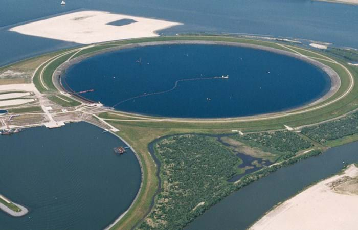
Ketelmeer, a lake in the Netherlands with a length of some 10 kilometers and a width varying from two to three kilometers, separates the North Eastern and Southern Polders constructed during the late 1960s and early 1970s. It is a major example of the problem of 'historic pollution'. Lake Ketelmeer receives the waters of the Rijn and IJssel and over a period of three or more decades, tens of millions of cubic meters of highly contaminated sediments entered Ketelmeer from hundreds of upstream locations. The bottom was covered by polluted sediments to an average depth of 50 cm. A significant proportion of this material had to be removed, or capped by the cleaner sediments of recent years, if a normal aquatic environment was to be restored.

The strategy for Ketelmeer was based on selective removal, in areas such as the main shipping channels, together with the construction of a permanent and fully isolated repository for contaminated dredged material. This facility, the IJsseloog, will serve both Ketelmeer and the entire northern region of The Netherlands and has a capacity of 23 million m3. When the facility is full, it is likely to be capped and developed as a recreational area within a rejuvenated Ketelmeer. This new island, with its adjacent wetland habitats, has the potential to become a significant nature reserve in its own right. The Boskalis system deployed at Ketelmeer had a capacity of 500 cu m/hr and had the ability to strip very thin layers (0.05 m to 0.60 m). The system featured on an environmental disc cutter (a horizontal rotating disc) with a visor on the dredge side. Boskalis contributed to two key objectives. The first was to achieve a significant reduction in the re-suspension of sediments, due to vessel traffic in the main channels and movements in the many small harbors around Ketelmeer. The second was to deepen the shipping channel from the IJssel to Lake IJsselmeer.
Related projects

Selected filters
29_Oct_04_D_isle__1__header.jpg

Construction drilling island and ice barriers, Kazakhstan

Agip Kazakhstan North Caspian Operating Company B.V. (Agip KCO), a consortium of eight leading oil companies, is active in the northern section of the Caspian Sea. The gas and oil reserves in this area were mapped out in 1998 and 1999. To allow for their exploitation, Boskalis International has created an artificial island measuring 225 x 225 meters, and underwater berms, for Agip KCO. Four years later, the time was ripe for the construction of the drilling island and ice barriers. Once they were in place, Agip KCO could start to extract and distribute the oil reserves.

LFH241124009_header.jpg

Cleanup petroleum harbor, Amsterdam

The Amsterdam Petroleum harbor on the North Sea Canal has been used for the storage and transshipment of oil products since its construction in 1887. Over many years routine operations and unchecked discharges resulted in severe contamination of the harbor.

Luchtfoto_milieubrochure_header.jpg

Cleanup, Ketelmeer

Ketelmeer, a lake in the Netherlands with a length of some 10 kilometers and a width varying from two to three kilometers, separates the North Eastern and Southern Polders constructed during the late 1960s and early 1970s. It is a major example of the problem of 'historic pollution'. Lake Ketelmeer receives the waters of the Rijn and IJssel and over a period of three or more decades, tens of millions of cubic meters of highly contaminated sediments entered Ketelmeer from hundreds of upstream locations. The bottom was covered by polluted sediments to an average depth of 50 cm. A significant proportion of this material had to be removed, or capped by the cleaner sediments of recent years, if a normal aquatic environment was to be restored.

Warnow_Tunnel__3__header.jpg

Tunnel construction Warnow, Rostock

The Warnow Tunnel is located in Rostock, Germany, at the old mouth of the river Warnow in the Baltic Sea. In the DDR period this area grew out to be the main harbor of East-Germany. After the 'turn' (die Wende) in 1989 the port more or less died. Goods came cheaper and quicker from Rotterdam, Bremen and Hamburg by rail.

Installation gas pipeline, Gelugor Mainline

The Gelugor transportation system is a 24'' gas pipeline from the Tenaga Nasional Berhad (TNB) Prai Power Station, Mainland Peninsular Malaysia across the Strait of Pinang to the TNB Gelugor Meter Station on Pinang island. The pipeline has a length of 6.4 km and was put into use in the beginning of 2000. Boskalis Offshore has constructed the protection of the pipeline with rock material. The function of the protection differs along the chainage of the pipeline. A shipping channel is situated between the island and the peninsular. The pipeline in the shipping channel has been covered for to protect against ship anchors (drop and drag).

Rosario_001_header.jpg

Fixed Link between Rosario and Victoria

The Joint Venture Boskalis International - Ballast Nedam JV was a subcontractor to the Consorcio Impregilo, Hochtief, Roggio and Techint which was awarded the construction of the fixed link between Rosario, in the province of Santa Fe and Victoria, in the province of Entre Rios. The Client in this project was the Argentine Government, and the leader of the Consorcio was Impregilo. The Consorciol executed all the civil constructions such as bridges while the JV Boskalis International – Ballast Nedam (BKI/BND) constructed, using sand only, the road embankments, connecting the several bridges.