To main content

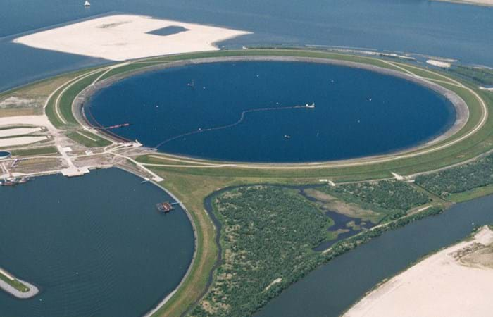
Cleanup, Ketelmeer

Ketelmeer, a lake in the Netherlands with a length of some 10 kilometers and a width varying from two to three kilometers, separates the North Eastern and Southern Polders constructed during the late 1960s and early 1970s. It is a major example of the problem of 'historic pollution'. Lake Ketelmeer receives the waters of the Rijn and IJssel and over a period of three or more decades, tens of millions of cubic meters of highly contaminated sediments entered Ketelmeer from hundreds of upstream locations. The bottom was covered by polluted sediments to an average depth of 50 cm. A significant proportion of this material had to be removed, or capped by the cleaner sediments of recent years, if a normal aquatic environment was to be restored.

The strategy for Ketelmeer was based on selective removal, in areas such as the main shipping channels, together with the construction of a permanent and fully isolated repository for contaminated dredged material. This facility, the IJsseloog, will serve both Ketelmeer and the entire northern region of The Netherlands and has a capacity of 23 million m3. When the facility is full, it is likely to be capped and developed as a recreational area within a rejuvenated Ketelmeer. This new island, with its adjacent wetland habitats, has the potential to become a significant nature reserve in its own right. The Boskalis system deployed at Ketelmeer had a capacity of 500 cu m/hr and had the ability to strip very thin layers (0.05 m to 0.60 m). The system featured on an environmental disc cutter (a horizontal rotating disc) with a visor on the dredge side. Boskalis contributed to two key objectives. The first was to achieve a significant reduction in the re-suspension of sediments, due to vessel traffic in the main channels and movements in the many small harbors around Ketelmeer. The second was to deepen the shipping channel from the IJssel to Lake IJsselmeer.
Related projects

Selected filters
Oman_-_the_Wave_I_header.jpg

Reclamation, dredging and excavation, The Wave

Through Orascom, the Omani government is developing their tourist and real estate sector in order to diversify its economical drivers. The Wave, Muscat is the first freehold tourism and residential development to be launched in the Sultanate of Oman. The USD 805 million project will stretch along 7 kilometers (4.35 miles) of beachfront land overlooking the Gulf of Oman and covers an area of approximately 2.5 million square meters (26.9 million square feet). It is located in Muscat, Oman's capital city, about 5 kilometers (3.1 miles) from Muscat’s Seeb International Airport.

f__Queen_of_the_Netherlands_def_header.jpg

Land reclamation and revetments works, Salam Yiti

Salam Yiti is located near the south of Muscat, about 40 minutes away from Muscat’s international airport, and minutes from the traditional business and hotel district of Qurum. The Salam Yiti development covers 420 hectares of land and climbs as high as 140 meters above sea level. The project is being developed at a cost of USD 1.7 billion. It was scheduled for completion by 2013. The development plan features luxury hotels, state-of-the-art spas, exclusive villas and apartments, and luxury townhouses set on the beach and in the mountains and select shopping and dining outlets, all surrounded by a championship golf course, marina, a wellness and eco-marine center.

angola_2_header.jpg

Dredging, reclamation and
shore protection, Soyo LNG

Angola is one of the world’s deep water oil exploration ‘hot spots’. More than 50 significant oil discoveries in Blocks 14, 15, 17 and 18 are believed to contain at least 10 billion barrels of oil. With the increase in oil production comes large quantities of associated gas. Historically, in the absence of a local market, associated gas has been flared or reinjected into the reservoirs. Sonangol, the state oil company, and some of its oil producing partners developed the Angola LNG Project to reduce flaring of gas and curtail gas injection. Angola LNG is a joint venture project involving the major oil producers in the country. Sonangol and Chevron are the co-leaders of the project; the other partners are Total, ENI and BP.

MBK2-2_header.jpg

Port expansion, Ras Laffan

The Ras Laffan project is one of the largest maritime engineering projects in the world. Its sheer size can best be viewed from space. Over a period of three years, more than 3,000 specialists have been working together to create the largest LNG harbor in the world. The total contract value is approximately USD 2 billion, with the Boskalis share amounting to 50%. Qatar has natural gas reserves of roughly 25 trillion m3, 15% of the world total. The gas is transported from the Offshore North Field (26,000 billion m3), 80 kilometers north of Qatar, into Ras Laffan, where it is liquefied and pumped into latest generation tankers.

Boskalis_Aerials_by_Lucas_Dawson__15__header.jpg

Channel deepening, Melbourne

To maintain its position as number one container and general cargo port in Australia, the Port of Melbourne Corporation (PoMC) proposed a plan to make the port accessible to 14m draught vessels during all tidal phases. Following the selection of a partner in April 2004 an Alliance Agreement was developed between PoMC and Boskalis Australia Pty Ltd, i.e, a contract where risk sharing was the norm and Boskalis could provide advice during the project development phase using its ‘in house’ expertise and experience.

klein_1_header.jpg

Gas fields development, Krishna Godavari basin

A large-scale dredging, trenching, pipe pulling and backfilling project. Reliance Industries develops the offshore gas field known as Block KGDWN-98/3 in the Krishna Godavari Basin, Bay of Bengal off the East Coast of India. The gas field will be linked to onshore customers and covers an area of approximately 7,500 km2. The field stretches an area 40 to 60 kilometers southeast of Kakinada. The scope of works comprised the dredging of a 21 kilometers long and 18 meters wide trench for three 24" gas pipelines, each with a 6" piggyback pipeline, one 12" effluent pipeline and two umbilical cables in water depths ranging from 0 to 50 meters. After pipe laying by the main contractor the pipeline trench was backfilled with partly rock and sand.