To main content

Cleanup, Ketelmeer

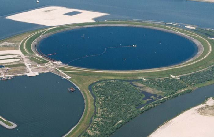
Ketelmeer, a lake in the Netherlands with a length of some 10 kilometers and a width varying from two to three kilometers, separates the North Eastern and Southern Polders constructed during the late 1960s and early 1970s. It is a major example of the problem of 'historic pollution'. Lake Ketelmeer receives the waters of the Rijn and IJssel and over a period of three or more decades, tens of millions of cubic meters of highly contaminated sediments entered Ketelmeer from hundreds of upstream locations. The bottom was covered by polluted sediments to an average depth of 50 cm. A significant proportion of this material had to be removed, or capped by the cleaner sediments of recent years, if a normal aquatic environment was to be restored.

The strategy for Ketelmeer was based on selective removal, in areas such as the main shipping channels, together with the construction of a permanent and fully isolated repository for contaminated dredged material. This facility, the IJsseloog, will serve both Ketelmeer and the entire northern region of The Netherlands and has a capacity of 23 million m3. When the facility is full, it is likely to be capped and developed as a recreational area within a rejuvenated Ketelmeer. This new island, with its adjacent wetland habitats, has the potential to become a significant nature reserve in its own right. The Boskalis system deployed at Ketelmeer had a capacity of 500 cu m/hr and had the ability to strip very thin layers (0.05 m to 0.60 m). The system featured on an environmental disc cutter (a horizontal rotating disc) with a visor on the dredge side. Boskalis contributed to two key objectives. The first was to achieve a significant reduction in the re-suspension of sediments, due to vessel traffic in the main channels and movements in the many small harbors around Ketelmeer. The second was to deepen the shipping channel from the IJssel to Lake IJsselmeer.
Related projects

Selected filters
Muuga_3_header.jpg

Expansion coal terminal, Muuga

The Muuga Coal terminal, sited on a bay, east of the existing port of Muuga, is to handle some five million tons of Siberian coal a year for destinations worldwide. The coal is shipped to Muuga by rail. Future developments may include container berths and steel facilities. The main contractor for the development of the Muuga coal terminal was the Estonian project management group A.S. Merko Ehitus. The dredging subcontract was awarded in late May 2003 to Terramare Eesti O.Ü., the Estonian arm of the Finnish-based Boskalis group company Terramare Oy.

29_Oct_04_D_isle__1__header.jpg

Construction drilling island and ice barriers, Kazakhstan

Agip Kazakhstan North Caspian Operating Company B.V. (Agip KCO), a consortium of eight leading oil companies, is active in the northern section of the Caspian Sea. The gas and oil reserves in this area were mapped out in 1998 and 1999. To allow for their exploitation, Boskalis International has created an artificial island measuring 225 x 225 meters, and underwater berms, for Agip KCO. Four years later, the time was ripe for the construction of the drilling island and ice barriers. Once they were in place, Agip KCO could start to extract and distribute the oil reserves.

Queen_Daya_Bay_300dpi_header.jpg

Port construction, Daya Bay

In Daya Bay, P.R. China, a USD 4.3 billion petrochemicals complex was being built by CNOOC and Shell Petrochemicals Company (CSPC). Daya Bay is located in the southwest of China, Huizhou Municipality, Guangdong Province. The project called for the construction of two marine facilities, one nearby the petrochemicals complex, the other one further offshore. Early 2004, the Boskalis International B.V. and Nanjing Changjiang Waterway Engineering Bureau (NCWEB) partnership commenced dredging for the CSPC Nanhai Petrochemicals project. Key requirement of the project was to preserve the sensitive environment in Daya Bay. Hydronamic, Boskalis’ own engineering consultancy, designed the required monitoring plan and took responsibility for its implementation.

luchtfoto_project.jpg

Creation artificial lagoon, Barcelona

Increasing or compensating nature is one of the challenges in modern infrastructural projects. Within the scope of the extension of the Port of Barcelona compensation was required for nature to be preserved. A natural reserve, south of the Port of Barcelona and north of the International Airport of Barcelona, had to be increased and was realized within the city limits of Prat de LLobregat by the use of the cutter suction dredger Para and its auxiliary equipment.

May_2004_header.jpg

Port development, Coega

The Coega port project - on Algoa Bay at the mouth of Coega River - is designed to act as a catalyst for regional economic development. The new port and its adjacent Industrial Development Zone, 20 km east of Port Elizabeth, are described as South Africa's largest infrastructural development scheme for a decade. 

LFH241124009_header.jpg

Cleanup petroleum harbor, Amsterdam

The Amsterdam Petroleum harbor on the North Sea Canal has been used for the storage and transshipment of oil products since its construction in 1887. Over many years routine operations and unchecked discharges resulted in severe contamination of the harbor.