To main content

Cleanup, Ketelmeer

Ketelmeer, a lake in the Netherlands with a length of some 10 kilometers and a width varying from two to three kilometers, separates the North Eastern and Southern Polders constructed during the late 1960s and early 1970s. It is a major example of the problem of 'historic pollution'. Lake Ketelmeer receives the waters of the Rijn and IJssel and over a period of three or more decades, tens of millions of cubic meters of highly contaminated sediments entered Ketelmeer from hundreds of upstream locations. The bottom was covered by polluted sediments to an average depth of 50 cm. A significant proportion of this material had to be removed, or capped by the cleaner sediments of recent years, if a normal aquatic environment was to be restored.

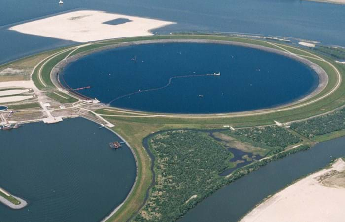
The strategy for Ketelmeer was based on selective removal, in areas such as the main shipping channels, together with the construction of a permanent and fully isolated repository for contaminated dredged material. This facility, the IJsseloog, will serve both Ketelmeer and the entire northern region of The Netherlands and has a capacity of 23 million m3. When the facility is full, it is likely to be capped and developed as a recreational area within a rejuvenated Ketelmeer. This new island, with its adjacent wetland habitats, has the potential to become a significant nature reserve in its own right. The Boskalis system deployed at Ketelmeer had a capacity of 500 cu m/hr and had the ability to strip very thin layers (0.05 m to 0.60 m). The system featured on an environmental disc cutter (a horizontal rotating disc) with a visor on the dredge side. Boskalis contributed to two key objectives. The first was to achieve a significant reduction in the re-suspension of sediments, due to vessel traffic in the main channels and movements in the many small harbors around Ketelmeer. The second was to deepen the shipping channel from the IJssel to Lake IJsselmeer.

Related projects

Selected filters
Loading_TSHD_by_CSD_header.jpg

Creation bird island, Le Havre port 2000

Le Havre is the fifth largest container port in Europe and is expanding its facilities: the current 14 quays for container vessels are to be expanded with another 12 (all outside the locks). Port 2000’s rationale centres on Le Havre’s determination to position itself as a leading hub.

hfd_onder_header.jpg

Creating two berths pockets, NCIG terminal

For 200 years the Port of Newcastle has been Australia’s premier coal export harbor. Of the 95 Mtpa of various commodities such as steel, aluminum, minerals and so forth exported from Newcastle in 2008-2009, 90.5 Mtpa were attributable to coal. Average annual growth rate of coal exports from 1990 to 2006 was 6.1%. This constant increase has caused a spike in ships queuing to enter the harbour to be loaded. To increase capacity and avoid these traffic jams, a decision was made to develop a new coal stockpile area and construct a third coal terminal.

Balboa_2_header.jpg

Port expansion, Balboa

The plans to expand the Panama Canal represent one of the most important infrastructure improvements of the 21st century. Since its opening in 1913 the Canal has provided the shortest and most economically viable shipping route from Pacific to Atlantic seaports. With the ever-increasing size of modern-day vessels, it was inevitable that the Canal would need to be widened and deepened. The expansion of the Canal has made the extension of the Port of Balboa at the mouth of the canal on the Pacific Ocean a necessity. The Phase 4 projects included Marine Works and Civil Works to improve two existing berths and to build a completely new berth capable of handling not only Post Panamax but also Super Post Panamax ships.

DSCF0226_header.jpg

Land reclamation, North Manama Causeway

The purpose of the project was to provide additional land to accommodate a section of a proposed new highway system to service the area and to relieve congestion on the corniche road. Boskalis appointed Hydronamic (the in-house engineering department of Boskalis) to provide detailed design and on site assistance with supervision of the sub-contractor for the rock works.

Figure_1_header.jpg

Port environmental mitigation measures, Hamina

Hamina, which is close to the Russian border in south-east Finland, is a home port for the oil industry and a transit harbor for timber, cars and other goods on their way to Russia. To provide access for larger vessels it had to deepen the existing channel by two meters to 12 meters and create a new channel section. Terramare Oy, a subsidiary of Royal Boskalis Westminster, won this assignment in late 2008. The project started in July 2009.

Raahe_1_header.jpg

Port development, Raahe

The Raahe project is the largest dredging contract in Finnish history. Access for larger ships is economically important for the clients using the port of Raahe, such as the steel company Ruukki.