To main content

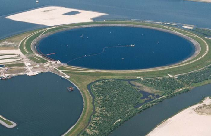
Cleanup, Ketelmeer

Ketelmeer, a lake in the Netherlands with a length of some 10 kilometers and a width varying from two to three kilometers, separates the North Eastern and Southern Polders constructed during the late 1960s and early 1970s. It is a major example of the problem of 'historic pollution'. Lake Ketelmeer receives the waters of the Rijn and IJssel and over a period of three or more decades, tens of millions of cubic meters of highly contaminated sediments entered Ketelmeer from hundreds of upstream locations. The bottom was covered by polluted sediments to an average depth of 50 cm. A significant proportion of this material had to be removed, or capped by the cleaner sediments of recent years, if a normal aquatic environment was to be restored.

The strategy for Ketelmeer was based on selective removal, in areas such as the main shipping channels, together with the construction of a permanent and fully isolated repository for contaminated dredged material. This facility, the IJsseloog, will serve both Ketelmeer and the entire northern region of The Netherlands and has a capacity of 23 million m3. When the facility is full, it is likely to be capped and developed as a recreational area within a rejuvenated Ketelmeer. This new island, with its adjacent wetland habitats, has the potential to become a significant nature reserve in its own right. The Boskalis system deployed at Ketelmeer had a capacity of 500 cu m/hr and had the ability to strip very thin layers (0.05 m to 0.60 m). The system featured on an environmental disc cutter (a horizontal rotating disc) with a visor on the dredge side. Boskalis contributed to two key objectives. The first was to achieve a significant reduction in the re-suspension of sediments, due to vessel traffic in the main channels and movements in the many small harbors around Ketelmeer. The second was to deepen the shipping channel from the IJssel to Lake IJsselmeer.
Related projects

Selected filters
IMG_0619_header.jpg

Port expansion, Gijón

The Spanish port of Gijón on the Bay of Biscay processes more than 12 million tonnes of bulk goods annually. With the expansion of global trade and increasing ship sizes, the terminal was lacking capacity to handle the traffic. The maximum draft for the ships of 18 meters is another obstacle to the development of the port. So the Port Authority of Gijón developed a plan for additional modern facilities in an area measuring 145 hectares to the north of the existing port. This includes a bulk terminal with a transfer capacity of more than 25 million tons and a storage area measuring 60 hectares for a maximum of 2 million tons of coal and iron ore a year.

5_Phase-2_header.jpg

Port development, Sevilla

Seville is located 80 km land inwards and it is Spain’s only commercial river port. Access is along the Rio Guadalquivir. The current dimensions and depth of the port impose limitations on the breadth and draughts of the vessels that use it, putting the future of the port at risk. So the Port Authority developed a New Maritime Approach that provides for the deepening and widening of the approaches to the port.

fremantle_1_header.jpg

Port expansion, Fremantle

Fremantle Ports is the Western Australian Government trading enterprise responsible for strategic management of the Port of Fremantle. The Port of Fremantle provides modern deep-water facilities for handling container trade, break-bulk vessels, livestock exports and motor vehicle imports as well as accommodating cruise ships.

IMGP4086.jpg

Extension cruise
terminal, the Bahamas

In April 2009 Royal Boskalis Westminster N.V. was awarded the contract for the extension of the cruise terminal in Nassau from the Ministry of Works and Transport of the Government of the Bahamas. The contract was worth approximately USD 44 million and the project was completed in the first six months of 2010.

_HP_0356_header.jpg

Dredging and reclamation, Port of Peterhead

The project consisted of capital dredging, reclamation, quay construction and breakwater extension works for Peterhead Smith Embankment Development, in order to develop the area in the north of the harbour at Smith Embankment to provide sheltered berths for vessels ranging from 20 to 160 m in length.

24012008_PLUTO_CSD_Phoenix__Samson_101_header.jpg

Dredging and construction, Pluto LNG project

The Pluto LNG project is located about 190 km northwest of the coastal town Karratha, in the Northern Carnarvon Basin, Western Australia. The project is a joint venture between Woodside Burrup Pty. Ltd., the operator, with a 90% interest, and Tokyo Gas (5%) and Kansai Electric (5%). The A$12 bn project will process gas from the Pluto and neighboring Xena gasfields.