To main content

Cleanup, Ketelmeer

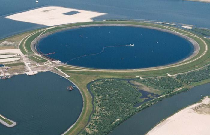
Ketelmeer, a lake in the Netherlands with a length of some 10 kilometers and a width varying from two to three kilometers, separates the North Eastern and Southern Polders constructed during the late 1960s and early 1970s. It is a major example of the problem of 'historic pollution'. Lake Ketelmeer receives the waters of the Rijn and IJssel and over a period of three or more decades, tens of millions of cubic meters of highly contaminated sediments entered Ketelmeer from hundreds of upstream locations. The bottom was covered by polluted sediments to an average depth of 50 cm. A significant proportion of this material had to be removed, or capped by the cleaner sediments of recent years, if a normal aquatic environment was to be restored.

The strategy for Ketelmeer was based on selective removal, in areas such as the main shipping channels, together with the construction of a permanent and fully isolated repository for contaminated dredged material. This facility, the IJsseloog, will serve both Ketelmeer and the entire northern region of The Netherlands and has a capacity of 23 million m3. When the facility is full, it is likely to be capped and developed as a recreational area within a rejuvenated Ketelmeer. This new island, with its adjacent wetland habitats, has the potential to become a significant nature reserve in its own right. The Boskalis system deployed at Ketelmeer had a capacity of 500 cu m/hr and had the ability to strip very thin layers (0.05 m to 0.60 m). The system featured on an environmental disc cutter (a horizontal rotating disc) with a visor on the dredge side. Boskalis contributed to two key objectives. The first was to achieve a significant reduction in the re-suspension of sediments, due to vessel traffic in the main channels and movements in the many small harbors around Ketelmeer. The second was to deepen the shipping channel from the IJssel to Lake IJsselmeer.
Related projects

Selected filters
gavle_hamn_201319_DD_Bewerkt_header.jpg

Port extension, Port of Gävle

The Port of Gävle is located on the east coast of Sweden in the Gulf of Bothnia, facilitating Swedish imports and exports. The client wished to improve maritime safety and accessibility, and to increase the throughput of goods in this harbor.

20120229-DSC_3214_header.jpg

Port expansion, Onne

In May 2011 Boskalis was awarded the project for the expansion of the Federal Lighter Terminal and Federal Ocean Terminal of the Onne Port Complex by Prodeco International Limited. The project entails the reclamation of approximately 200 ha with suitable materials from nearby borrow areas.

Boskalis_Genova_VOLO_ph-merlo_110112-3725_header.jpg

Port upgrade, Genoa

The deepening and extension of the port of Genoa is needed to accommodate the larger container vessels and the ferries of MSC. The client is the Port Authority of Genoa. The project is being executed by Boskalis Italia S.r.l. in a joint venture with Tecnis S.p.A., an Italian company that is responsible for the construction work.

B_nieuw_header.jpg

Port and MOF, LNG plant Barrow Island, Gorgon

Design and construction of a new port and materials offloading facility in a class 'A' nature reserve. The project owner is developing LNG process facilities on Barrow Island off the north west coast of Western Australia approximately 140 km west of Dampier and 95 km north east of Onslow. Barrow Island is a Class A Nature Reserve and an internationally important conservation estate.

DSC_5770_header.jpg

Port development, Mombasa

The Port of Mombasa is currently the biggest port on the coast of East Africa north of Durban, and the only international port in Kenya. It is now in the throes of a huge expansion drive to both increase cargo handling capacity and accommodate Panamax and Post Panamax vessels. The port is a transit route for, mainly, Uganda, Rwanda, South Sudan and Northern Tanzania. The current container terminal has an installed capacity of 250,000 TEU but handled more than 770,000 TEU in 2011. The port will raise its profile as a regional hub by building a second container terminal with a capacity of 1.2 million TEU. The port authority decided to construct the container terminal in phases.

_Group_4_-_DSC7015__DSC7024-3_images_header.jpg

Port development, Tanger Med 2

Tanger-Med is a cargo and passenger port located about 40 km east of Tangiers, Morocco, on the Straits of Gibraltar at the crossing of two major maritime routes only 15 km from the European mainland.