To main content

Cleanup, Ketelmeer

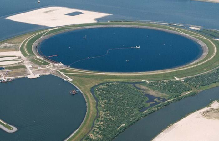
Ketelmeer, a lake in the Netherlands with a length of some 10 kilometers and a width varying from two to three kilometers, separates the North Eastern and Southern Polders constructed during the late 1960s and early 1970s. It is a major example of the problem of 'historic pollution'. Lake Ketelmeer receives the waters of the Rijn and IJssel and over a period of three or more decades, tens of millions of cubic meters of highly contaminated sediments entered Ketelmeer from hundreds of upstream locations. The bottom was covered by polluted sediments to an average depth of 50 cm. A significant proportion of this material had to be removed, or capped by the cleaner sediments of recent years, if a normal aquatic environment was to be restored.

The strategy for Ketelmeer was based on selective removal, in areas such as the main shipping channels, together with the construction of a permanent and fully isolated repository for contaminated dredged material. This facility, the IJsseloog, will serve both Ketelmeer and the entire northern region of The Netherlands and has a capacity of 23 million m3. When the facility is full, it is likely to be capped and developed as a recreational area within a rejuvenated Ketelmeer. This new island, with its adjacent wetland habitats, has the potential to become a significant nature reserve in its own right. The Boskalis system deployed at Ketelmeer had a capacity of 500 cu m/hr and had the ability to strip very thin layers (0.05 m to 0.60 m). The system featured on an environmental disc cutter (a horizontal rotating disc) with a visor on the dredge side. Boskalis contributed to two key objectives. The first was to achieve a significant reduction in the re-suspension of sediments, due to vessel traffic in the main channels and movements in the many small harbors around Ketelmeer. The second was to deepen the shipping channel from the IJssel to Lake IJsselmeer.
Related projects

Selected filters
_Group_4_-_DSC7015__DSC7024-3_images_header.jpg

Port development, Tanger Med 2

Tanger-Med is a cargo and passenger port located about 40 km east of Tangiers, Morocco, on the Straits of Gibraltar at the crossing of two major maritime routes only 15 km from the European mainland.

TSHD_Cornelis_Zanen_rainbowing_header.jpg

Port upgrade, Pointe Noire

The rehabilitation of the Port of Pointe-Noire focused on the renovation and upgrading of the main infrastructure of the port and its adaptation to developments in containerized traffic, offering a draught of -15 m. Furthermore, the work included the construction of a protective berm, an extension of the external breakwater, the rehabilitation and extension of quays, and dredging work.

DSC_0602_header.jpg

Land reclamation artificial island, Punta Pacifica

The shoreline of Panama has increasingly become densely populated and, as the economy has boomed over the past 10 years, there is strong demand for high-end products. The real-estate market has taken a revolutionary step with the completion of the the first artificial real-estate island in the Americas.

19DS9430_12-11-26_005_header.jpg

Construction LNG port, Swinoujscie

The protective breakwater for Swinoujscie External Port comprises a 3 km long breakwater and groyne for a new outer harbor construction to facilitate a LNG tanker berth and other related activities in the Baltic Sea. The construction of the breakwater took 2 ½ years and was completed in December 2012. Boskalis International B.V. was the leader of a consortium consisting of Boskalis International B.V., Hochtief, Aarsleff and Doraco.

Aeroview_D1207-944_header.jpg

Port expansion,
Maasvlakte 2

PUMA, the Project Organization for the Extension of the Maasvlakte, is a 50/50 joint venture between dredging and marine contractors Boskalis and Van Oord. The consortium has been contracted by the Rotterdam Port Authority to construct the first phase of the Maasvlakte 2 Project – the extension of the Port of Rotterdam – between 2008 and 2013. The new zone will encompass 2,000 hectares of new land, roughly the same size as the total surface area of Schiphol airport. Half of the area will become land for a future business park.

Gbaran_Ubie_filter_placement_header.jpg

Riverbed and slope protection, Gbaran Ubie

The Shell Petroleum Development Company of Nigeria Limited (SPDC) has constructed a gas processing facility in the Niger Delta on the outside bank of a bend of the River Nun at Gbaran Ubie, north of Yenagoa. To facilitate the importation of the processing modules, a Materials Offloading Quay was constructed, including a ro-ro ramp, a passenger jetty and a fire water station.