To main content

Dredging, reclamation,
reconstruction and environmental
monitoring works, Vilufushi

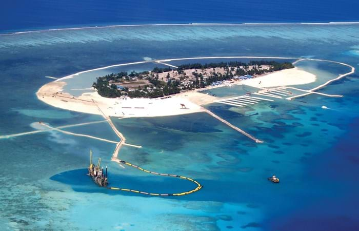
The Republic of the Maldives consists of 1,190 small coral islands grouped into 26 atolls. Only 200 islands are inhabited. On 26 December 2004, a tsunami originating from Indonesian waters struck the Maldives. This natural disaster had major economic, social and environmental consequences. Of the 200 inhabited islands, 13 were totally destroyed and 56 suffered major damage, including the island of Vilufushi in Thaa Atoll. Houses and infrastructure were heavily damaged. All the surviving residents had to be evacuated to the neighboring island of Buruni to the west of Vilufushi. The government of the Maldives decided to reconstruct the entire island and to extend it considerably by landfilling the shallow reef. Boskalis International was appointed for this work.

Several alternatives were studied. The plan that was finally adopted involved dredging coral sand from an area off the northern reef edge of Vilufushi with a medium-sized cutter suction dredger. The sand was then pumped directly into the area to be filled. The reconstruction included:

  • Removal of all debris.
  • Dredging and reclamation of 1 million m3 of coral sand from the reef to increase the surface of, and raise, the island.
  • Construction of a 2000 meter rock revetment around the island as a breakwater to protect against wave penetration.
  • Dredging of a new harbor to 3 meters below sea level.
  • Construction of a 350 meter quay wall using pre-cast concrete elements.
  • Construction of a 350 meter breakwater to protect against wave penetration. 

Monitoring during dredging and reclamation

The Maldives have a very rich marine biodiversity, which requires safeguarding through special measures, in particular during dredging and reclamation activities. A special monitoring program was required to monitor changes in environmental parameters with an adverse impact.
Related projects

Selected filters
DSC03484_header.jpg

Cleanup, Westergasfabriek

The Westergasfabriek was built by the British firm Imperial Continental Gas Association (ICGA) in 1883, and was at the time the biggest coal-fired gas factory in Amsterdam. The project site, covering four hectares, housed coal storage yards, gasometers, purification plants, a water tower and office buildings, all designed by the famous Dutch architect Isaac Gosschalk. The municipal energy company used the site for storage into the early 1990s.

Bahrain_header.jpg

Land reclamation, Shaikh Khalifa Bin Salman Causeway

The Shaikh Khalifa Bin Salman Causeway is located in the State of Bahrain in an expanse of water called the Khawr Al Qulayah. It connects the Hidd Drydock Highway to the Mina Sulman Port. This major infrastructure project is carried out in advance of the planned expansion of the Bahrain port activities. This New Port project is planned at the Hidd side and via the Shaikh Khalifa Bin Salman Causeway direct connected with the existing Mina Sulman port and Saudi Arabia. The total length of the Shaikh Khalifa Bin Salman Causeway is approximately 6,500 m, including a bridge of 400 m, which was constructed in 2000.

Oresund.jpg

Tunnel construction Øresund, Denmark - Sweden

The Øresund Tunnel forms part of the Øresund Link that connects the cities of Copenhagen in Denmark and Malmö in Sweden across the Øresund.

Chek_Lap_Kok__09-06-1995.jpg

Land reclamation Check Lap Kok airport Hong Kong

In 1996 Hong Kong was a modern city-state with almost 6 million inhabitants where air traffic was a very important component for economic activity. The old airport Kai Tak, with a single runway, was no longer able to cope with the growing number of passengers and amount of freight.  The authorities decided to build a new, bigger airport at a new location in Hong Kong, a 350 hectares hilly island off the coast about 28 km west of the city center.