The Port of Adelaide is the primary port in South Australia, located at Outer Harbor. The port is operated by Flinders Ports Pty Ltd (Flinders Ports) and handles both container and cruise vessels, contributing significantly to the State’s economic activity. Flinders Ports identified the need for an upgrade of the existing infrastructure driven by the emergence of Post Panamax class vessels. To meet this growth the existing channel had to be widened to accommodate vessels with a maximum width of 49 m without operational restrictions. Flinders Ports contracted Boskalis to execute the dredging works.
SCOPE
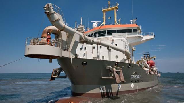
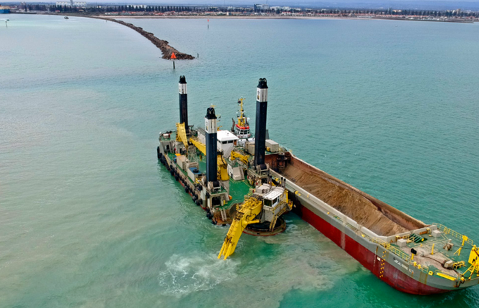
Dredging works included the widening of the existing access channel by 40 m to a total width of 170 m and the swing basin from 505 to 560 m and to a depth of -14.2 m LAT. The dredged material was transported to a designated dredge material placement area, located approximately 30 km offshore in the Gulf of St. Vincent. Dredging works were undertaken by the TSHD Gateway and the BHD Magnor assisted by a plough vessel and barges. A total volume of 1.5 million m3 nett was dredged in approximately 3 months.
EARLY CONTRACTOR INVOLVEMENT
Boskalis was appointed as preferred contractor in October 2018 and assisted from this moment in time in obtaining the Dredge Licence together with Flinders Ports, engineering consultant Arup and environmental consultant BMT. The dredge licence was granted by the Environmental Protection Agency of South Australia (EPA) on the 12th of March 2019. Environmental management plans were written in close collaboration between all parties, ensuring commencement of dredging works in time.
ENVIRONMENT
Environmental protection was of utmost importance for the executing of the project. Seagrass meadows are present adjacent the access channel for which stringent turbidity limits applied and seagrass surveys were undertaken prior and post dredging works. The project was partly located in the Adelaide Dolphin Sanctuary, hosting several resident and transient dolphin species, for which marine mammal monitoring was undertaken by the dredge crew. Prior to the works, razorfish present at the seabed in the channel had to be removed to prevent the potential spread of the Pacific Oyster Mortality Syndrome to South Australia’s important oyster farming industry. Finally, the overseas and interstate dredge vessels obtained a thorough cleaning prior to arrival in South Australia to adhere to Australia’s biofouling guidelines in order to prevent the importation of invasive marine species.
STAKEHOLDERS
Stakeholder management was key to the project’s success. Flinders Ports conducted a large community engagement campaign, which resulted in no complains during the works. During the works, continuous engagement between the EPA, Boskalis and Flinders Ports occurred to remain informed.
ADAPTIVE MANAGEMENT
During the works, dredge activities had to be managed to remain within the set turbidity thresholds. This was done through The Adaptive Management System in close cooperation with the client and the Environmental Protection Agency. Real-time turbidity monitoring data and knowledge on the operations and the environment ensured effective measures could be taken. During the works however, four events occurred where the upper threshold was exceeded, exuberated by severe weather. The EPA acknowledged that poor weather conditions contributed to the high turbidity levels on occasion and allowed the dredge operation to continue without harming the environment.
TEAM-WORK
The spirit of cooperation and the open communication within in the project team, as well with the Client and relevant stakeholders was excellent. It's also worth mentioning that almost half the project team consisted of female colleagues working on board of dredgers, on hydrographic surveys, environmental issues, planning, logistics and the secretarial side.
SAFETY
To prevent incidents during mooring and unmooring, the BHD Magnor is equipped with a mooring actuator. The mooring actuator was developed to eliminate personnel risks and to optimize the dredging process. The system is a remotely constant tensioning mooring system, which eliminates the need to manually handle the mooring lines for the barges coming along side to be loaded.However no firm requirement, but as a result of increasing awareness for pollution, biodegradable hydraulic oil was used in all the hydraulic systems on the project.
HR
All vessels on the project were operated by a mix of expatriate professionals and Australian seafarers. Personnel was given project specific training to assure the best outcome for the project:
-
Mammal observation training
-
Heritage training
-
Environmental compliance training
-
Project and visitor inductions